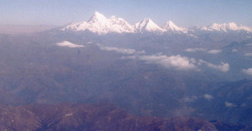
Himavat
Himavat means "icy" or "snowy"
in Sanskrit, the word can also be translated as the "God of Snow",
or the "Himalayan Mountain(s)".
In this part of my website I will enlist
some mountains with religious significance in Asia (Tibet, China,
Pakistan, India, Bhutan...), but this may not be a strict rule here,
as I will not omit some lakes and possibly other places of certain
importance or uniqueness.
To quickly see the mountains with religious significance in Asia,
choose from the following list: Afghanistan
and Pakistan, Kazakhstan (and other post-Soviet
countries), Kashmir (India), Himachal
Pradesh (India), Uttarakhand (India),
China (Tibet), Sikkim (India),
West Bengal (India), Arunachal
Pradesh (India), Nepal, Bhutan,
and Sri Lanka. The list of the countries is not
complete here, as some of them, like Myanmar, contain only one mountain
and I did not make a link to it here (although I have the entry Myanmar
here). Please, use the above links as your roadmap in your search
for Lord Himavat.
Since I like a certain order (and peculiarities,
too :), I would prefer that you imagine, together with me, the map
of Asia (particularly Northern India) and only then please read this
information about the mountains. However, the first mountain in the
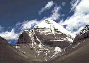
list will be Mount Kailash, as Hindus and Buddhists believe it is
the most sacred place in the world.
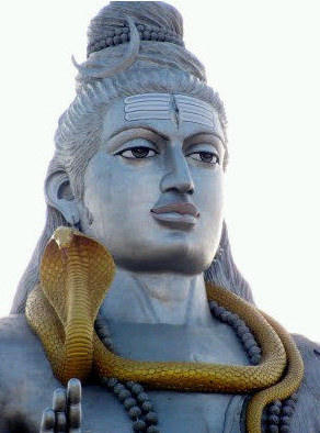
 Mount
Kailash
Mount
Kailash
Mount Kailash (6,638 m) is a holy peak in China. It lies near the
source of some of the longest rivers in Asia. Four religions consider
it a sacred place: Bön, Buddhism, Hinduism,
Jainism. In Hinduism, it is considered to be the abode of Lord
Shiva. The ancient Zhang Zhung
culture of Tibet concentrated around this mountain as well.
Afghanistan
Noshaq
Noshaq (or Nowshak, 7,492 m) is the highest mountain in Afghanistan.
It is part of the Eastern Hindu Kush range. I did not find any legends
associated with this mountain, because Afghanistan is the worst mapped
and worst documented country in the world. However, the Hindu Kush
is abundant with legends, but in the worst documented country, which
has struggled in wars for many years, mostly locals will tell you
a story. Nuristan, a region in Afghanistan in the south of the Hindu
Kush valleys, was converted to Islam much later than other parts of
the nearby regions (Pakistan, Iran). A kingdom in Afghanistan is mentioned
in the Mahabharata - the name Afghanistan
is most probably derived from Sanskrit.
This was the place from where Gandhari came from and it is probably
the origin of the word Kandahar, the second largest city in Afghanistan.
You will be surprised, but there is still a minority of Hindus living
in Afghanistan.
The highest mountains in Afghanistan are: Noshaq, Ql Sorkhi (6,171
m), Shah Dhar (7,038 m); many of the Afghanistan's mountains (including
Noshaq) are on the international boundary with Pakistan.
Pakistan
Hunza
Hunza Valley is one of the most exotic places in the world. The valley
provides spectacular views of some of the most astonishing mountains
- Rakaposhi (7,788 m), Ultar Sar (7,388 m), Bojahagur Duanasir II
(7,329 m), Ghenta Peak (7,090 m), Hunza Peak (6,270 m), Darmyani Peak
(6,090 m), and Ladyfinger Peak (6,000 m). Hunzakuts, the people of
the Hunza Valley, speak the Burushaski language, which resembles Basque;
both languages (Basque and Burushaski) are language isolates.
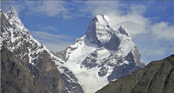
The picture of Shispar Peak (near Hunza
Valley). The picture was taken from
this website. There are some
other websites, just
look.
Ganesh Village
Many people in the Hunza Valley are like Europeans in appearance.
In Ganesh Village (also spelled as Ganish Village and known, too,
as Ganish Khun) there are some most amazing ancient inscriptions carved
on rocks and in ancient scripts such as Karoshti, Gupta, etc. The
age of some of them is estimated to go back as far as 5,000 years
BC.
Some people say that Hunza Valley is a place that can be associated
with the lost kingdom of Shambala (Shangri-la).
For centuries, the Hunza Valley, like some mountainous ranges in Afghanistan
and India, has been one of the most isolated territories in the world.
It is known that King Suchandra came from Shambala (some say that
Shambala was a kingdom north of Kashmir) to request and receive the
Kalachakra teachings from Shakyamuni Buddha.
K2
K2 (8,611 m) is the second highest mountain on Earth. K2 and many
other high mountains in Pakistan are part of the Karakoram mountain
range. The beauty of Karakoram (like we can see in our Slovak High
Tatras) is in concentration of its peaks.
Sakar Sar Peak
Sakar Sar (6,272 m) is in the Chapursan Valley of Gojal
(Hunza). A shrine of Baba Gundi (also written as Ghundi), a saint
from Afghanistan, is here (in a village). According to a local legend,
Baba Gundi came in the valley asking for food but he only received
it from an old woman. So he decided to punish the whole valley and
sent flood and mud on it - he destroyed everything in it (the village,
too) except the old woman.
Ladyfinger Peak
Bublimoting or Ladyfinger Peak is a distinctive rock spire (6,000
m) in the westernmost subrange of the Karakoram Range of mountains
in Pakistan. It is named after an unfortunate Hunza princess Bubuli.
A local legend says that her husband, king Kiser, a mythical ruler
of Tibet, seated Bubuli on this granite spire. Ladyfinger Peak is
a surrounding peak of Uttar Peak (7,388 m).
Buni Zom
Buni Zom Mountain (6,551 m, near the border with Afghanistan) is
one of the most unexplored mountain areas in the world. The Buni Zom
Group has many other peaks, some of which have never been climbed.
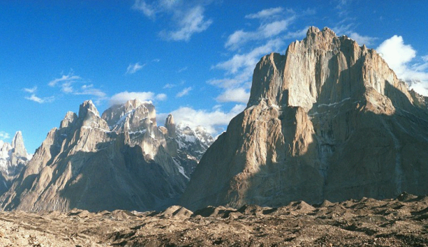
Karakoram (the picture of the
Baltoro Muztagh Range / Baltoro Cathedrals).
Tirich Mir
Tirich Mir (7,708 m), alternatively also called Terichmir or Turch
Mir, is the highest mountain in the Hindu Kush region and the highest
mountain outside of the Himalaya-Karakoram range (near Afghanistan).
According to local legends, no one can climb this mountain because
of demons and fairies who live there in it. Locals believe that this
mountain is the abode of fairies.
The highest mountain in Pakistan is K2 (8,611 m), which is the second
highest mountain in the world.
Muztagh Tower in the Karakoram range in
Pakistan.
Other important peaks in Pakistan are: Khunyang Chhish (7,852 m),
Masherbrum (7,821 m), Batura Sar (7,795 m), Kanjut Sar (7,760 m),
Rakaposhi (7,788 m), Disteghil Sar (7,885 m), Gasherbrum IV (7,925
m), Gasherbrum III (7,952 m), Trivor (7,577 m), Sia Kangri (7,442
m), Momhil Sar (7,343 m), Skil Brum (7,360 m), Shispare (7,611 m),
Saltoro Kangr (7,742 m).
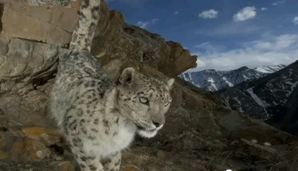
Snow Leopard is one of the
most enigmatic animals in the world; it lives in very high altitudes
(up to 6,000 meters). It is the "big cat of the Himalayas".
In addition to Nepal, Bhutan and the Chinese Himalayas (and Russia,
Mongolia, etc.), it lives in Pakistan (Chitral, Karakoram…) and in
India, particularly in the Indian states of Himachal Pradesh, Kashmir
(J and K), Uttarakhand, Sikkim, and Arunachal Pradesh (in the Eastern
Himalayas). A very good video
on youtube will tell you more.
Kazakhstan
Pik Talgar
Pik Talgar (4,979 m) is a peak in the Tian Shan mountain range in
Kazakhstan, named after the Talgar River and the city Talgar, which
lies in the southeastern part of Kazakhstan somewhere near the border
with Kyrgyzstan and China.
Kazygurt Holy Mount
Kazygurt Holy Mount is a place enveloped in legends and mostly in
connection to a righteous person named Nukhepaigambar (Noah). It lies
in the Kazygurt District (southern Kazakhstan) very near the border
with Uzbekistan and its capitol, Tashkent.
Khan-Tengri
Khan-Tengri (Lord of the Spirits, with elevation of 7,010 m) is one
of the most spectacular peaks of the central Tien-Shan. This mountain,
too, has long been wreathed in legends.
Other important peaks and places in Kazakhstan: Belukha Mountain
(with 4,506 m, the peak shares the border with Russia) - the highest
peak in Siberia and the Altai.
Kyrgyzstan
Jengish Chokusu
Jengish Chokusu, with 7,439 m above the sea level, is the highest
mountain in the Tian
Shan mountain range.
The Sulayman Mountain
The Sulayman Mountain (also known as Taht-I-Suleiman) is the world
heritage site in Kyrgyzstan. It is not very high and I could not find
its elevation. It is located very near the city of Osh (with many
legends going back to times of the biblical King Solomon) and it was
once a significant place of Muslim and pre-Muslim pilgrimages. The
mountain rises abruptly from the surrounding plains of the Fergana
Valley. Sulayman was also an important prophet in the Qur'an.
Tajikistan
Ismoil Somoni Peak
Ismoil Somoni Peak (7,495 m) is the highest mountain in Tajikistan.
It is named after Ismoil Somoni, the ancestor of the Samanid dynasty.
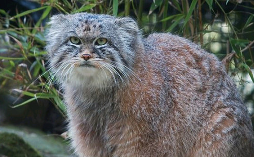
Pallas's Cat (or Otocolobus
Manul) is a small wild cat, a very little brother of Snow Leopard;
it is named after the German naturalist Pallas. Manuls (these little
cats) live primarily in central Asian grassland regions (Mongolia,
Siberia, China, Tibet, Kyrgyzstan, Kazakhstan, Uzbekistan, Iran, Afghanistan,
Tajikistan...) and in high altitudes, too (some even up to 5,000 m).
Like Snow leopard, Manul is an endangered species.
Kashmir (India)
Gumbok Rangan
Gumbok Rangan (5,320 m) is a rocky precipice located in the Kurgiakh
Valley of Zanskar, India, in the Indian state of Jammu and Kashmir.
Local inhabitants consider it sacred. Mani walls (stone tablets or
stones engraved with prayers and put together) can be found at the
foothills of the Gumbok Rangan precipice.
Harmukh
Harmukh is a mountain in Jammu and Kashmir in the Himalayas. It has
a height a little more than 5,000 m above the sea level. This place
and its surroundings is considered sacred and to be the abode of Lord
Shiva.
One of the highest mountains in Kashmir (Jammu and Kashmir): Stok
Kangri (elevation 6,153 m).
Takht-i-Sulaiman
Sankaracharya Temple, also known as the Jyesteswara Temple, sits
on top of the hill Takht-i-Sulaiman, or "Throne of Solomon"
near Srinagar in Jammu and Kashmir. The temple is known for its inscriptions
on the stairs leading to the shrine and some people use them as a
proof that Jesus visited the temple (Holger Kersten wrote the book
about this: Jesus Lived In India).
China - Xinjiang
Gaochang Mountains
Tianshan Mountain is a large mountain range that starts in central
Xinjiang and stretches into Kazakhstan. The Flaming or Gaochang Mountains
are known by a legend that says that a dragon lived in the Tianshan
Mountains. Because the dragon ate little babies, a Uigur hero decided
to slay it.
The highest peaks of Xinjiang are: Gasherbrum II East (7,758 m),
Kongur Tagh (7,649 m), Skyang Kangri (7,545 m), Muztagata (6,884 m),
Xiaofong Tip (6,845 m).
The world's second highest mountain, K2 (8,511 m), is situated on
the Xinjiang's southern border with Pakistan.
Himachal Pradesh (India)
Chamba Kailash
The Manimahesh Kailash Peak (5,653 m), also known as Chamba Kailash
- and similar in appearance to Mount Kailash in Tibet, stands towering
high over the Manimahesh Lake. Like Mount Kailash, the Manimahesh
Kailash Peak, too, is believed to be the abode of Lord Shiva. It is
one of the most important religious sites in Himachal Pradesh. The
Manimahesh Lake is at the base of the Chamba Kailash Peak and people
of Himachal Pradesh hold both in deep veneration.
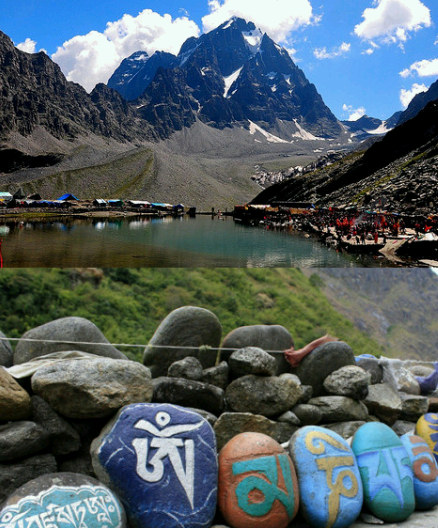
Two pictures assembled into
one - Chamba Kailash (top) with Mani walls (bottom) found on many
places in Tibet / India.
Kinnaur Kailash
The Kinnaur Kailash (6,500 m) is a mountain in the Kinnaur district.
The Kinnaur Kailash, too, is considered sacred (both by Buddhists
and Hindus).
Rewalsar
The most sacred spot for Buddhists in Himachal Pradesh. According
to a legend, Guru Padmasambhava departed for Tibet from this spot
to spread the dharma. A pagoda-style monastery stands along the edges
of the lake. Mandi, a city in Himachal Pradesh, houses Rewalsar, the
place from which Buddhism spread to Tibet on the wings of Padmasambhava
(the Lotus Born). Padmasambhava also transmitted Buddhism to other
parts of Asia (Bhutan). Guru Rinpoche and Padmasambhava is one person.
Parvati Valley
The name itself says that this valley in the Indian state of Himachal
Pradesh is tightly related to Goddess Parvati.
A beautiful city in Parvati Valley, Manikaran (with altitude of 1,760
m), attracts tourists very much - it has hot springs and pilgrim centers.
The Hindus believe that Manu (the Hindu equivalent of Noah) recreated
life in Manikaran and it is therefore a sacred area. It has many temples
and a Gurudwara (a place of worship for the Sikhs). According to a
legend, when Lord Shiva and his half, Parvati (His spouse), once walked
in the valley, Parvati dropped one of her earrings. Shesha-Nag,
a serpent deity, seized it and immediately disappeared into the
earth with it. He did not want to give it back to Parvati, which angered
Shiva very much. Shesha-Nag surrendered only after Shiva performed
His cosmic dance (known as Tandava).
The highest peaks in Himachal Pradesh are: Manirang (6,593), Shilla
Peak (6,132 m), Shipki (5,669 m).
Uttarakhand (India)
Kalanag
Kalanag (6,387 m) captivated my interest because of its two words
- kala (meaning black) and nag (meaning a snake or cobra).
Neelakant
Neelakant (or Nilkantha - meaning a blue throat
in Sanskrit) towers over the valley of the Alaknanda River and rises
6000 m above the Hindu holy town of Badrinat. It is the most important
of the four sites in the India's Char
Dham pilgrimage. A legend says that there was no mountain on the
spot where Nilkantha stands today. Lord Shiva
blocked here the way personified as a huge mountain and this is how
Nilkantha came into existence. However, the most famous story related
to Shiva's blue throat (that is - Neelakant) is in the Puranas
- Lord Shiva drank the lethal poison (Halahala) during the churning
of the ocean, but His spouse, Goddess Parvati, stopped the poison
from entering His body. The poison remained in the Lord Shiva's neck
and His neck is therefore blue.
Om Parvat
Om Parvat (also known as Adi Kailash, or Little Kailash) is a mountain
(6,191 m) in Uttarakhand, India. It is considered sacred by Hindus.
Its appearance is similar to the shape of Mount Kailash in Tibet.
Two wonderful lakes are situated nearby - Lake Parvati and Lake Jonglingkong.
Lake Jonglingkong is sacred, too, and Hindus perceive it similarly
as Lake Manasarovar.
Trisul
Trisul is a group of three Himalayan peaks grouped near on the ridge
of one mountain massif; the highest one is Trisul I reaching 7,120
m. The three peaks resemble the Lord Shiva's (and the Parvati's) trident
- in Sanskrit and in some other Indian languages (such as Hindi),
Trishul is the trident, the weapon of Lord Shiva. Goddess Ambika in
Devi
Mahatmyam also fights Asuras with the trident.
Swargarohini
Swargarohini is a mountain massif (6,252 m) consisting of four separate
peaks in the Bandarpunch Range of the Garhwal Himalaya. Swargarohini
is the main peak of the four peaks. It is associated with legends
that tell that the Pandavas visited it. Some other legends say that
it is the only way one can approach the heaven with human body. This
indicates that traces of Shambala are probably here - the mystical
kingdom that allegedly disappeared from the Earth's surface.
Bandarpunch
Bandarpunch (or Bandarpoonch) is a peak (6,316 m) whose name suggests
that it is associated with Lord Hanuman.
When translated, it means "Tail of the monkey", or "Tail
of Hanuman" in Hindi. To say it more accurately, Bandarpunch
is a twin peak - it consists of Bandarpunch-I and Bandarpunch-II.
Many visitors come here every year. Kalanag (6,387 m) or Black Peak,
which is mentioned above, is very near Bandarpunch.
Haathi Peak
Haathi Peak (Elephant Peak) or Haathi Parvat (6,727 m) lies in Uttrakhand.
Locals say that the two huge rocks on a spur of Haathi Parvat represent
Kaaka (crow) and Garuda (a mythical bird, Lord
Vishnu's vehicle).
Hardeol
Hardeol or "Temple of God" (7,151 m) is one of the major
peaks in the Uttarakhand state. It is one of the highest peaks on
the northern side of the ring of peaks guarding the Nanda Devi Sanctuary.
Rishi Pahar
Rishi Pahar (6,992 m), as the name indicates, is "The
Peak of the Saint".
Nanda Devi
Nanda Devi (7,816 m) is the second highest mountain
in India (excluding Pakistan occupied Kashmir) and the highest entirely
within the country. The Nanda Devi Raj Jat Yatra is a famous pilgrimage
here and in vogue since the time immemorial (the word Nanda means
happiness or paradise in Sanskrit; Nanda Devi can be translated as
Goddess of Paradise).
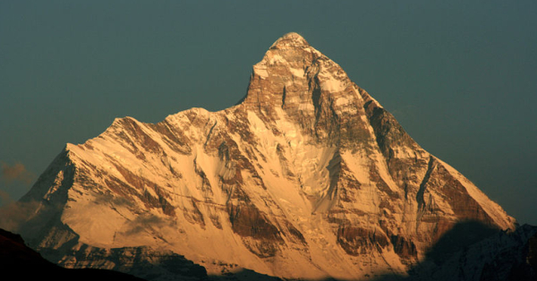
On the picture you see Mother Goddess (Nanda
Devi) - Mother Of Bliss (or Mother who bestows bliss) and one of the
highest peaks of India.
Gangotri
Gangotri is a town in the state of Uttarakhand, India, where the
River Ganges originates. This place is considered to be the seat of
Goddess Ganga. It is a Hindu pilgrim town.
Chandrashila
The Chandrashila Peak (Moon Mountain, 3,679 m) is a rock face positioned
above the temple of Tungnath. Climbing the peak will reward visitors
with the most spectacular view of the Himalayas, especially with the
view of Nanda Devi and Trisul. The (Shiva) temple here is one of the
highest situated of all the temples in the Himalayas. It belongs to
one of the five most sacred places of the Shaivite (dedicated to Lord
Shiva) branch of Sanatana Dharma. There are various legends associated
with this place. The five places
(Pancha Kedar), where devotees worship
Lord Shiva, manifested as different parts of the Lord Shiva's holy
body - the navel at Madmaheshwar, the arm at Tungnath,
the face at Rudranath, the matted hair at Kalpeshwar.
Kedarnath (which makes the number five full) is considered
to be the main temple, and Chota Char Dham are "the four smaller
abodes" (and a pilgrimage circuit). All five holy temples are
in very high altitudes (Rudranath is the only temple below the altitude
of 3,000 meters). The Lord Shiva temple at Kedarnath is said to have
been built by the Pandavas. Some other legends say that the Pandavas
built all the five temples here. The history of the above five holy
temples is attached to a legend that says that the Pandavas, after
they killed their brothers in war (read my brief
overview of the Mahabharata), felt guilty and wanted to approach
Lord Shiva, but He repeatedly kept His real
physical appearance (that is - His human-like form that can speak,
smile, etc.) from them and took the form of a bull. But the Pandavas
recognized Him and followed Him everywhere, so He decided to disintegrate
His body. All five holy temples are situated between the rivers Bhagirathi
and Alaknanda, and all are in the Indian state of Uttarakhand.
Rajrambha
Rajrambha is the name of a Himalayan peak (6,537 m) meaning a "celestial
nymph" (Apsara). There may be some legends that associate this
place with fairies. The peak has most probably been the same source
of myths as we can find in relation to Tirich Mir (a mountain in the
Hindu Kush).
Nanda Kot
Nanda Kot (6,861 m) is a mountain peak in the Himalayas. When translated
it means the "Nanda's Fortress". As the name suggests ("Nanda's
Fortress"),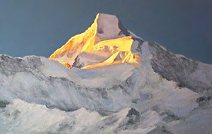 it is the abode of Goddess Parvati. The mountain is extremely beautiful;
looking at it you may get a feeling that you are not in the real world
but in the place where science fiction begins (see the picture on
the left).
it is the abode of Goddess Parvati. The mountain is extremely beautiful;
looking at it you may get a feeling that you are not in the real world
but in the place where science fiction begins (see the picture on
the left).
Nag Tibba
Nag Tibba (3,022 m) is the highest peak in the lesser Himalayan region
of the Uttarakhand state. Nag Devta (Naga serpent) lives here, as
the name indicates. To be more accurate, Nag
Devta is God of Snakes (of Nagas). In Hindu mythology, the great
king of the Nagas is Vasuki (a divine being). Buddhists, too, have
stories about snake people in their myths.
Mana Peak
Mana Peak (7,272 m) lies on the border with China (Tibet-India) with
Mana village at its foot. Mana village is famous in history as Veda
Vyasa lived here in a cave for many years. People believe that
Lord Ganesha wrote the epic "Mahabharata"
here (with His tusk) as Veda Vyasa dictated it to Him. There are many
other legends related to Mana village, Mana Peak and its neighborhood.
The highest mountains in Uttarakhand: Nanda Devi (7,816 m), Kamet
(7,756 m).
Haryana (India)
Samlasan Devi
Samlasan Devi is a 788 m hill in Haryana, India.
Tamil Nadu (India)
Arunachala
Arunachala (800 m) is the holy hill at Thiruvannamalai in Tamil Nadu
with a holy temple. Every year in October-November, the Karthigai
Deepam (Light) is lit atop the hill. It is the most important place
for people practicing Atma vichara (self
enquiry, the teaching of Sri Ramana Maharshi) and one of the five
main Shaivite holy places of South India.
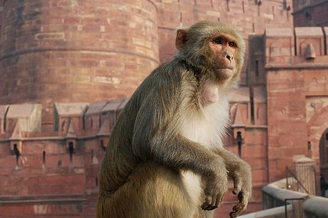
Rhesus macaque (Macaca mulatta),
or Rhesus monkey, is one of the most well known species of monkeys
in Asia. It lives in northern India but in other countries, too -
in grasslands, woodlands, and mountainous regions up to 2,500 m in
elevation.
China (Tibet and other parts)
Kawagebo
Kawagebo (6,740 m) is famous for its pilgrims; it is the highest
mountain in Yunnan, China. It is in Tibet near the border with Myanmar.
It has a very nightmarish climbing history - an avalanche in 1991
killed 17 members of one expedition. Many other expeditions, too,
were unsuccessful. In 2001, the local government banned climbing onto
this mountain.
Mianzimu
Mianzimu (6,054 m) is a sacred mountain in China.
Shishapangma
Shishapangma (8,013 m) is the fourteenth highest mountain in the
world and the lowest of all eight thousand meter peaks.
Mount Gephel
Mount Gephel is a small mountain some 8 kilometers west of Lhasa.
Drepung Monastery lies at its foot.
Gurla Mandata
This spectacular massif (7,694 m) decorates the western section of
the Himalayas in Tibet. Gurla Mandata is a close neighbor of the sacred
Mount Kailash, which lies to its north. The local inhabitants call
it Namo Nanyi (or Namo Nani), the "Fairy's Peak". Lake Manasarovar
and Lake Langatso are situated nearby.
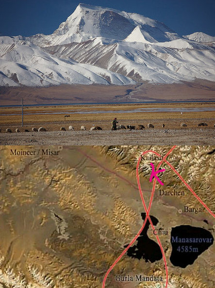
Gurla Mandhata is the highest
peak of the Nalakankar Himal, a small (sub)range of the Himalayas.
It is situated near Mount Kailash, as you see on the map (below Gurla
Mandhata). The letter "K"
in glaring red is the place where Mount Kailash
is on the map.
Gambo Utse
Drepung is the largest of all Tibetan monasteries and it is located
on the Gambo Utse Mountain, some five kilometers from the western
suburb of Lhasa. Jamyang Choge Tashi Palden founded the monastery
in 1416. Its name comes from a sacred abode in South India (Shridhanyakataka).
Jomolhari
Jomolhari (7,314 m) is a mountain in the Himalayas on the Bhutan-Tibet
border. The mountain is sacred to Tibetan Buddhists who believe it
is the abode of one of the Five Tsheringma Sisters (protector goddesses
of Tibet and Bhutan).
Cho Oyu
Cho Oyu is the sixth highest mountain in the world with 8,201 m above
the sea level. Cho Oyu lies in the Himalayas and is some 20 km west
of the Mount Everest at the border between China and Nepal. Cho Oyu
means "Turquoise Goddess" in Tibetan. It is a holy mountain
to the locals.
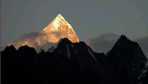
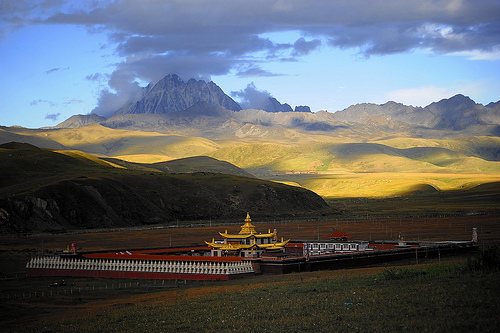
Mount Kailash
Mount Kailash (6,638 m) is a peak in China. It is the most sacred mountain
for the Hindus. Kailash (also called Shenshan) is locally more known
as Kangrinboqe.
Zhara Lhatse
This sacred mountain (5,820 m) in Tibet is located in the Tawu County.
Five holy mountains make up this place facing Lhagang, the nearby
village: Chenresig, Jambayang, Chana Dorje, Drolma, and Zhara. Guru
Rinpoche (Padmasambhava) is connected with this place.
Any look at Zhara Lhatse is
both scary and inspiriting.
Chokpori
Or Chagpo Ri, the "Iron Mountain", is a sacred hill in
the city of Lhasa, Tibet. It lies south of the Potala (sacred Buddhist
complex of buildings).
Tongshanjiabu
Tongshanjiabu (7,207 m) is a mountain in the Himalayas. It sits on
the disputed border territory between Bhutan and China. No one has
ever officially climbed it.
Gyala Peri and Namcha Barwa
Gyala Peri (7,294 m) is a peak sitting at the entrance to Tsangpo
gorge (a canyon in Tibet). The best-known myth related to this peak
is the story of Namcha Barwa and his younger brother, Gyala Peri;
God sent them to guard Tibet. They play the same role of spiritual
teachers as Tonpa Shenrab mibo,
the founder of the pre-Buddhist Tibetan religion called Bön. Namcha
Barwa (7,756 m) is the name of a nearby peak. These are the companion
peaks.
Mount Emei
This is (3,099 m) one of the four Sacred Buddhist Mountains in China,
traditionally regarded as the bodhimaa, or place of enlightenment.
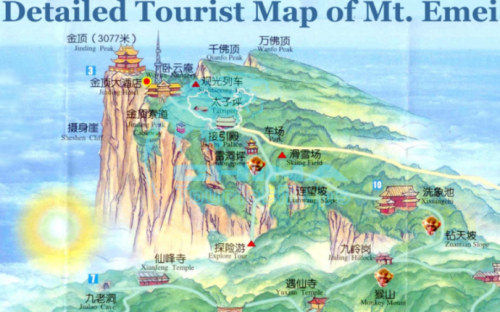
Mount Emei is the place of
enlightenment.
Lakes
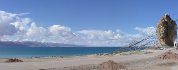
Lake Manasarovar
Lake Manasarovar (4,556 m) is a fresh-water lake in Tibet some 800
kilometers from Lhasa. To the west of Lake Manasarovar lies Lake Rakshastal
and towards the north Mount Kailash. It is the highest (of such size)
situated fresh-water lake in the world. Buddhists also associate the
lake with the legendary lake known as Anavatapta in Sanskrit (believed
to exist in the center of the world), where Queen Maya conceived Buddha.
A few monasteries decorate places near the lake's shores. The most
notable of them is the ancient Chiu Gompa Monastery, which was built
right onto a steep hill.
Lake Rakshastal
Lake Rakshastal is a lake in Tibet, lying close to Lake Manasarovar
and Mount Kailash. Lake Rakshastal does not share the same spirit
with its eastern neighbor. Meaning "lake of the rakshasa",
Lake Rakshastal is considered to be the residence of Ravana, the ten-headed
demon of Lanka. Lake Manasarovar, which is round like the sun, and
Lake Rakshastal, which has a shape of the crescent moon, are regarded
as "day" and "night". Lake Rakshastal has salty
water, which is in a stark contrast to the fresh water of Lake Manasarovar.
According to Hindu scriptures, King Ravana created this lake with
a wish to garner superpowers through devotional acts to
Lord Shiva.
Yamdrok Lake
Yamdrok Lake, too, is one of the holy lakes in Tíbet.
Namtso
Namtso, the highest saltwater lake (4,718 m) on Earth, is the "heavenly
lake"; it possesses a few wonderful islands that have been used
as spiritual retreats for many years. Local people believe that back
in very ancient history Lake Namtso was a portal to heaven. It is
a place where God's name, if whispered, God may possibly also hear.
Mongolians know it as Tengri Nor, the "Sky Lake". It is
enveloped in many celestial myths.
Lake Namtso is very near Lhasa
- see
the map.
Assam (India)
The hills in the Indian state of Assam are the least explored corners
of India. The world's largest river island, Majuli, is situated on
the Brahmaputra River here. It is the centre of the Vaishnava culture
with Vaishnava monasteries. The monasteries are called satras.
Nagaland (India)
Nagaland borders with Assam; it is situated in the easternmost corner
of India together with Arunachal Pradesh. Mount Saramati is the highest
peak in this Indian state. Nagaland is mostly a Christian state, but
its name is derived from the Nagas
(snakes).
Sikkim (India)
Siniolchu
Siniolchu (6,888 m) is one of the highest mountains in the Indian
state of Sikkim. The mountain is considered to be a particularly beautiful
mountain. It is situated near the green lake adjacent to Kangchenjunga,
the highest peak in the state and the third highest in the world (it
shares its border with Nepal).
West Bengal (India)
Sandakfu
Sandakfu or Sandakphu (3,636 m) is the highest peak in the state
of West Bengal, India.
Phalut
Phalut or Falut (3,600 m) is the second highest peak of West Bengal,
India.
Bihar (India)
Barabar Caves
Barabar Caves are situated in the Barabar Hills, at a distance of
some 25 km to the north of Gaya, Bihar (Gaya is a large city in Bihar).
These hills are famous for their rock-cut caves. These caves were
constructed during the reign of Emperor Ashoka some 200 years BC.
Champanagar
Champanagar, a Buddhist pilgrimage center, with name derived from
the Champak tree (a large evergreen tree growing in abundance here),
is situated in the Bhagalpur district of Bihar. Buddha delivered a
number of sermons here. It lies some 220 km away from the capital
city of Patna (capitol of Bihar). This place is significant for Buddhists
because Lord Buddha visited it in person.
Pragbodhi
Pragbodhi Mountain is situated in the state of Bihar. The name Pragbodhi
literally means "Prior to Enlightenment". The mountain derives
its name from the sojourn of Prince Siddhartha here before his enlightenment.
The legends say that Prince Siddhartha spent the time of his asceticism
in a small cave here.
Gurpa
Gurpa is a sacred mountain, which is situated in a small village
in the Indian state of Bihar. This magnificent mountain is associated
with Maha Kassapa, the successor of Buddha.
Gurpa (picture on the left)
is the place associated with the future Buddha and thus it has always
carried both the message of Buddhism and prophecies of Buddhism. There
are not many Buddhist places so visibly connected with the future
as Gurpa.
Manipur (India)
Manipur is known for its Longthabal, a small hill situated a few
kilometers from the capital city of Manipur. This place is full of
relics and ruins of ancient palaces and temples.
Mizoram (India)
The highest mountain in this Indian state is Phawngpui (2,157 m).
Phawngpui means Blue Mountain.
Tripura (India)
This Indian state is surrounded mostly by Bangladesh and it does
not have very high mountains, but it has rich myths. Its name could
be derived from Tripura Sundari. This is
a very ancient location where the Manikya Dynasty ruled for hundreds
of years. The capitol of Tripura is Agartala and probably also the
place where the word Agartha originated (Agartha is an underground
kingdom of a very advanced civilization; some people believe it is
a myth, some other people believe
it really exists).
Meghalaya
This Indian state is known for its splendid waterfalls. The highest
mountain here is Maryngksih (1,525 m).
Arunachal Pradesh (India)
Takpa Shiri
Takpa Shiri is an unclimbed peak with unique religious significance;
it lies in the Kangto part of the Himalayas. Located at an altitude
of some 6,654 m (not all sources agree and it is difficult for me
to find a good and reliable map) in the state of Arunachal Pradesh
on the border with China and India, it is one of the most sacred mountains
here. Locals believe that circling the Takpa Shiri delivers a spiritual
bliss. Unfortunately, much of the ancient traditions have disappeared
due to border disputes and difficulties with crossing the border.
Circumambulation of the Takpa Shiri equals to circumambulation of
the Mount Kailash.
Mishmi Hills
The Mishmi Hills extend from Arunachal Pradesh to Assam. Ruins of
ancient temples are here (for example, on the Nilachal Hill in Assam).
However, much of the Mishmi Hills belongs to the Dibang Valley district
of Arunachal Pradesh. The mountains have elevation of about 4,500
m above the sea level. Many of the shrines here were used as places
where human sacrifices were practiced (source: History Of Upper
Assam by L. W. Shakespear, 1914).
Other peaks of Arunachal Pradesh: Kangto, Nyegi Kangsang, and the
Gorichen Peak are the highest peaks in this part of the Himalayas.
Uttar Pradesh (India)
This Indian state borders with Nepal. I noticed a lot of false information
that confuses Uttar Pradesh with the Indian state of Uttarakhand.
When you look at the terrain map of India, you will notice that this
Indian state is mostly a flat land.
Vindhya Mountains (Uttar Pradesh, Madhya Pradesh, India)
The intelligent birds that the Markandeya
Purana mentions lived on the Vindhya Mountains. Goddess Shakti
says (in Devi Mahatmyam): "Then born as the offspring of Yasoda's
womb in the cowherd Nanda's house, and dwelling on the Vindhya Mountains
I will destroy them both" (She speaks of Shumbha and Nishumbha,
the great Asuras that she destroys).
The Vindhya Mountains are not very tall (about 1,000 m); they divide
the southern and northern India. Their highest point is Amarkantak,
a pilgrim town in Madhya Pradesh.
There are four most (well-known)
deadliest snakes In India - Naja Naja (the Indian Cobra), the Common
Krait (or Bungarus caeruleus), the Russell's Viper (Daboia Russellii,
also known as Vipera Russellii), and a very aggressive viper called
Echis carinatus - the Saw-Scaled Viper. Naja Naja is widespread and
you may find it (and other poisonous snakes) also in the Himalayas
up to some few thousand meters above the sea level. Vipera Russellii
is one of the most dangerous vipers in India. The King Cobra (it lives
in the vicinity of the Himalayas, and in Bengal, Assam, South India
too) is rarely reported, although very poisonous, too. There are not
many encounters reported with humans, because the King Cobra is a
reclusive snake (therefore usually not mentioned in the list of the
most dangerous snakes of India).
Nepal
Kangchenjunga
The area around Kangchenjunga is a place where the Kangchenjunga
Demon has its throne - a type of yeti or rakshasa. A British geological
expedition in 1925 reported spotting a bipedal creature here and this
is probably how the Yeti myth got to the West. Located along the India-Nepal
border, it is the third highest mountain (with 8,586 m) in the world
after Mount Everest and K2.
Annapurna
Annapurna (8,091 m) is a Sanskrit name (anna - cooked and ready-to-eat
rice; purna - full) that can be translated as "Goddess of the
Harvests". In Hinduism, Annapurna is "the universal and
timeless mother who feeds" (Annapurna Devi).
Machapuchare
Machapuchare or Machhapuchhre (6,993 m), "Fish Tail" in
English, is a mountain that local people consider sacred and they
associate it with Lord Shiva.
Makalu
Makalu (8,463 m) is the fifth highest mountain in the world. Makalu
is an isolated peak with shape of a four-sided pyramid.
Khumbila
Khumbila or Khumbu Yul Lha (5,761 m), the name can be translated
as "God of Khumbu", is one of the Himalayan peaks in the
Khumbu region of eastern Nepal. Local Sherpa people consider it too
sacred to be climbed.
Ama Dablam
Ama Dablam is a mountain in the Himalayan range of eastern Nepal.
Climbers consider it to be the "Himalayan Matterhorn" (with
6,856 meters above the sea level). Ama Dablam means "Mother's
Necklace"; the long ridges on each side of the mountain look
like the arms of a mother (ama) who protects her child.
The highest peaks in Nepal are: Mount Everest (8,850 m), Kanchenjunga
(8,586 m),
Lhotse I (8,501 m), Makalu I (8,463 m), Cho Oyu (8,201 m), Dhaulagiri
(8,167 m), Manaslu I (8,163 m), Annapurna (8,091 m).
Bhutan
Jomolhari
Mount Jomolhari (about 7,000 m above the sea level) is in Bhutan
on the Bhutan-Tibet border. The mountain is sacred to Buddhists;
several other sacred sites sit on the Mount Jomolhari's back including
meditation caves. Jomolhari Temple (wedged into the rocks of this
mountain, but on the Bhutanese side) is one of few temples in the
world situated in altitude of more than 4,000 meters above the sea
level.
Jomolhari Temple is situated
in higher elevation above the sea level than Tungnath, some say (it
is difficult for me to verify the exact elevation). I did not find
any picture of it. This means that Bhutan is still a mystery and will
remain such for a long time.
Paro Valley
Legend has it that Guru Padmasambhava, the tantric mystic who brought
Buddhism to Bhutan in 747 AD, was riding on the back of a flying tiger
here - (tigress) Yeshe Tsogyal - a semi-mythical female deity (dakini
/ yogini). Paro Valley, with plenty of attractions, is one of the
most beautiful places on Earth with elevation of more than 2,000 m
above the sea level.
Kula Kangri
Kula Kangri (7,538 m), which lies on the border with China, is the
highest mountain in Bhutan.
Myanmar (Burma)
Hkakabo Razi
Hkakabo Razi (around 5,800 m) is the Southeast Asia's highest mountain,
located in the northern Myanmar state of Kachin.
Sri Lanka
Sri Pada
Sri Pada or Adam's Peak (2,243 m) is the highest Sri Lanka's mountain.
Lord Buddha left his footprint here. Hindus consider it to be the
expansion of Lord Shiva's Mount Kailash in the southernmost part of
the Indian subcontinent (with Sri Lanka), and Muslims believe that
the first human being, Adam, lived here. There is a nice
website here.
Back